School Mapping
To map every school in the world and show their connectivity in real-time.

There is an increasing number of children who don’t have access to education. It is estimated that by 2030, 60 million children won’t have access to primary education and since 2007, the global rate of school enrollment has stagnated.
Climate change and global conflicts are only exacerbating this issue, by increasing the number of children who are on the move and difficult to reach for education. And it’s not just a question of getting kids into school, but what kind of infrastructure and information they are receiving once they are there. Particularly, in this rapidly changing world — where the information and skills that children will need to be successful are increasingly more science and technology-based.
What we are working on.
UNICEF Innovation is building a tool using high-resolution satellite imagery and applying Deep Learning techniques to map every school in the world. The data generated and visualized through an online platform will help identify where the gaps and information needs are, serve as evidence when advocating for connectivity and help national governments optimize their education systems. It will also allow us to measure vulnerabilities and improve our emergency response and resilience against natural disasters and crisis.
We believe that the tool will provide actionable insights by identifying information needs and advocating for optimally positioned resources on the basis of evidence in different areas.
Education
- Learn more about how connectivity affects learning outcomes and how students receive information.
- Understand how connectivity can be used to support learning and to provide relevant, personalized content.
Infrastructure
- Better provide fast connectivity to schools.
- Advocate with governments for equitable access.
Emergency response
- Measure vulnerabilities.
- Improve preparedness and response in emergencies such as epidemics and natural disasters.
Platform for collaboration
- Create a platform for different partners to collaborate.
- Ensure countries are learning from each other.
- Ensure that NGOs and other stakeholders are coordinating.
A closer look.
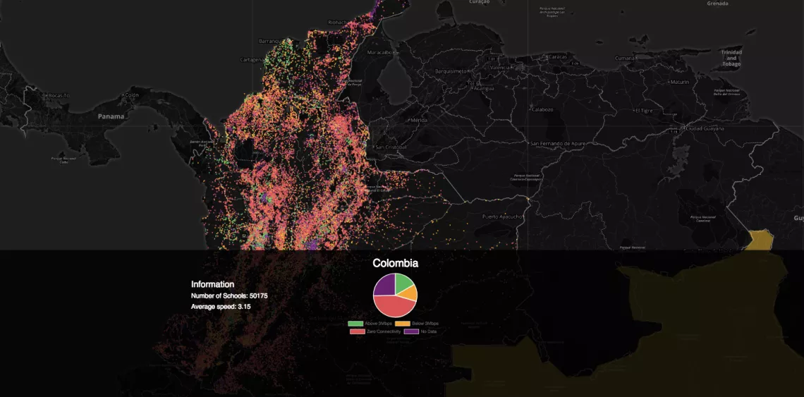
We currently have data on schools from several countries such us Brazil, Colombia, Kyrgyzstan, Liberia, Malawi, Mauritania, with over 100,000 data points collected. To support this work, UNICEF has also conducted research and case studies in few countries (i.e. research in the Amazonas region, showcasing the use of satellite connectivity to bring to bring secondary education to remote areas or remote, hard-to-reach areas).
Mapping every school in the world is a challenging task. Thus, we are exploring different methodologies and approaches that include:
- Collecting and combining existing data from governments, international organizations such as UNICEF and other non-profits working in the field.
- Crowdsourcing
- Combining Satellite imagery and Machine Learning techniques to automatically map schools. Partnering with Development Seed (https://developmentseed.org/) and UC San Diego’s Big Pixel Initiative (http://bigpixel.ucsd.edu/), we are developing Convolutional Neural Network-based classification algorithms which take advantage of underlying patterns recognized from high resolution satellite imagery to extract school locations.
UPDATE: UNICEF wins Digital Globe GBDX for Sustainability Challenge. Out of 70 submissions – we’ve been chosen as the select 5 using geospatial big data to address global challenges.

The Government of Kyrgyzstan has started a reform program called “Taza Koom”, aimed at digital transformation of the Kyrgyz Republic towards sustainable economy, transparent governance and smart society by 2030. Within this context, UNICEF Kyrgyzstan, in collaboration with the government, is mapping every school in the country, measuring their connectivity in real-time and combining it with overlays from different data sources. By integrating this data within the Magic Box platform, the national stakeholders will have a real-time connectivity map of these schools as well as additional insights that will help them understand and optimize the efficiency of the education system in supporting children’s access to education and 21st century skills.
As of March 2017, 30% of schools in Kyrgyzstan were connected to Internet, which is expected to increase up to 60% during 2017-2018 school year. However, the quality of the connection depends on the region and 40% of schools are still left without Internet.The tool that we are building will help advocate for connectivity and it will ultimately improve the delivery of learning content through this connectivity. It will also help identify gaps, measure vulnerabilities and risk and optimize emergency response and service delivery.
